Project Highlights | |
|---|---|
| Location | Northern Saskatchewan, Canada |
| Ownership | 100% |
| Status | Early-stage Athabasca Basin exploration projects with potential for high-grade, basement-hosted and Rössing-style uranium deposits. Available for option. |
| Commodity | Uranium |
Birch Project
The Birch Uranium Project (“Birch”) comprises four mineral claims totalling 5,751 hectares located approximately 35 kilometres north of the Athabasca Basin margin, and has potential for unconformity-related, basement-hosted deposits and bulk tonnage Rössing-style uranium deposits. Birch remains underexplored with no drilling to date.
As follow-up to Government regional airborne radiometric surveys, historical prospecting between 1968 and 1970 identified widespread and voluminous uranium-bearing pegmatites in the Box Lake Area (Figure 1 – Birch Project Block A). Individual pegmatites were traced over lengths exceeding 150 metres and widths exceeding 30 metres, with average sampled grades ranging from 200 to 300 ppm. Notably, higher grades were also recorded where structures could be sampled with grades between 0.22% and 0.36% U3O8. Uranium mineralization included uraninite and carnotite staining. Exploration is warranted to, 1) re-investigate the pegmatite uranium occurrences, 2) establish the nature and extent of the structurally-associated higher grade uranium mineralization (which would be expected to predominantly occur in low-lying areas with sediment/water cover), and 3) explore for extensions of these two types of mineralization to the south-southwest into a large favorable hinge zone target area of structural complexity which appears to be largely unexplored. To the south (Figure 1 – Birch Project Block B), ground radiometric anomalies were identified during historical prospecting at Miller Lake (equivalent uranium grades of up to 861 ppm eU), within a smaller hinge zone, also warranting modern follow-up.
Fir Project
The Fir Uranium Project (“Fir”) comprises a single mineral claim of 794 hectares located approximately ten kilometres north of the Athabasca Basin margin, and has potential for unconformity-related, basement-hosted deposits and bulk tonnage Rössing-style uranium deposits. Fir remains underexplored with no drilling to date.
A historical pebble sample assayed 55.06% U3O8, one of several radioactive pebbles found in a low-lying area covered by muskeg. An additional historical uranium occurrence of 0.24% U3O8 from an outcrop sample is present 400 metres to the southeast. The area is characterized by interpreted structural complexity at the intersection of east and northeast trending structures. Follow-up of the occurrence was limited to localized prospecting, and the occurrence warrants more detailed systematic follow-up, particularly in low-lying areas with surficial cover where structures are likely to exist.
In addition to the uranium potential, pegmatite outcrops enriched in Rare Earth Elements (“REE”) were discovered during historical prospecting for uranium. This included an outcrop sample of 2.4% Total Rare Earth Elements (“TREE”), and a 400 x 200 m outcrop of “white granodiorite” displaying broadly elevated TREE content and highlight grades from four samples of 1.1% to 1.9% TREE. High-value Nd and Pr account for approximately 20% of the TREE content. These historical REE occurrences warrant follow-up to determine the extent and grades of the mineralization. Far northern Saskatchewan has a precedent for high-grade pegmatite REE deposits, including Alces Lake (grades up to 30% TREE), Bear Lake (16% TREE rock sample), and Hoidas Lake (historical NI 43-101 mineral resource estimate including 2.6 million tonnes at 2% TREE).
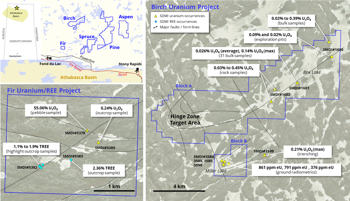
Figure 1: Birch and Fir Uranium Projects.
Similar to other recently announced uranium projects, Fortune Bay may seek to find a suitable partner/s to advance the Birch and Fir Projects through an earn-in, or similar agreement, that provides Fortune Bay with upside in future discovery.
Technical Disclosure
The historical results presented here have not been verified and there is a risk that any future confirmation work and exploration may produce results that substantially differ from the historical results. The Company also cautions that historical results on adjacent properties are not necessarily indicative of the results that may be achieved on the Project. The Company considers these historical results relevant to assess the mineralization and economic potential of the property. Further details regarding the historical occurrences mentioned in this news release can be found within the Saskatchewan Mineral Deposit Index (“SMDI”) using the reference numbers provided in Figure 1. Additional information has been obtained from historical reports found within Saskatchewan Mineral Assessment Database (“SMAD”) with the following Assessment File Numbers 74O10-0002, 74O10-0003, 74O10-0008 (Birch Project), and 74O09-0023, MAW02300 (Fir Project). Details regarding the other REE occurrences in far northern Saskatchewan can be found using the following references/links: Alces Lake: Appia Rare Earths and Uranium Corp. (https://appiareu.com/alces-lake/); Bear Lake: SMDI#3571; Hoidas Lake: SMDI#1612.
Qualified Person
The technical and scientific information presented here has been reviewed and approved by Gareth Garlick, P.Geo., Technical Director of the Company, who is a Qualified Person as defined by NI 43-101. Mr. Garlick is an employee of Fortune Bay and is not independent of the Company under NI 43-101.
Cautionary Statements
Information set forth on this webpage may contain forward-looking statements that are based on assumptions as of the date of posting. The reader is referred to the cautionary language contained within the respective Project’s News Releases, in addition to this website’s Terms of Use specifically including Forward Looking Statements.