Project Highlights | |
|---|---|
| Location | Northern Saskatchewan, Canada |
| Ownership | 100% |
| Status | Early-stage Athabasca Basin exploration project with potential for high-grade, basement-hosted and Rössing-style uranium deposits. Available for option. |
| Commodity | Uranium |
The Aspen Uranium Project
The Project comprises seven mineral claims covering an area of 9,869 hectares, located approximately 30 kilometres north of the Athabasca Basin, and approximately 35 kilometres northwest of the town of Stony Rapids. The Company’s Pine and Spruce Uranium Projects are located approximately 10 kilometres and 25 kilometres to the southwest, respectively. The three newly acquired projects cover approximately 35,000 hectares including 25 kilometres of strike length along the Grease River Shear Zone (“GRSZ”), a major underexplored structural corridor with potential for Athabasca-style basement-hosted deposits. The Aspen claims were acquired through staking, apart from a single claim of 595 hectares that was acquired from a third-party, arms-length vendor for a small cash payment and a 2% Net Smelter Returns (“NSR”) royalty. One-half of the NSR royalty can be purchased from the vendor at any time for C$500,000.
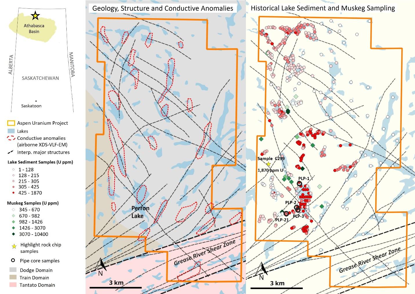
Figure 1: Aspen Uranium Project.
Historical Exploration and Uranium Endowment
This section provides a summary of relevant results from historical exploration. The reader is referred to the Technical Disclosure section at the bottom of this page for details on the sources of this information and cautionary notes.
During the late 1970’s historical operators undertook surface sampling campaigns and airborne geophysical survey as follow-up to an initial, highly anomalous, regional lake sediment result of 989 ppm U in Perron Lake. Surface sampling and follow up of radiometric anomalism included lake sediment sampling, muskeg sampling, and rock chip sampling. A statistical summary of the surface sampling results (as compiled from historical assessment reporting) is provided in Table 1, and sample locations and results are shown in Figure 1. These surface sampling campaigns identified exceptionally high uranium anomalism within organic-rich sample media (lake sediments and muskeg).
Table 1: Statistical Summary of Historical Surface Sampling Results.
| Lake Sediment Samples | Muskeg Samples | Rock Chip Samples | |
|---|---|---|---|
| Number of Samples | 439 | 24 | 291 |
| Average (U ppm) | 302 | 2,007 | 7 |
| Max (U ppm) | 1,870 | 10,400 | 140 |
| Min (U ppm) | 1 | 345 | 0 |
| Standard Deviation (U ppm) | 238 | 2,225 | 10 |
More detailed investigation of the lake sediment anomalies was conducted at Perron Lake during the late 1970’s, where the initial regional sample yielding 989 ppm U was collected. Perron Lake is located in the south-central area of the Project and has a surface area of approximately 122 hectares. Work included the collection of 53 lake sediment samples on a rough grid that yielded an average of 533 ppm U (maximum 1,870 U ppm, minimum 19 ppm U), as shown in Figure 1. In addition, three pipe core holes were completed within Perron Lake, with an additional hole completed within a smaller neighbouring lake to the west. The objectives of the pipe core holes were to investigate the nature of the lake sediment profile and to define the distribution of uranium, and other uranium pathfinder elements (copper and nickel). Overall, this coring revealed a lake sediment profile consisting of upper organic material transitioning to lower clay-rich sediments. In three of the four holes completed the uranium contents increased with depth (up to a maximum concentration of 900 ppm U). These anomalies remain open at depth, as shown in Figure 2, potentially indicating bedrock sources beneath the lakes.
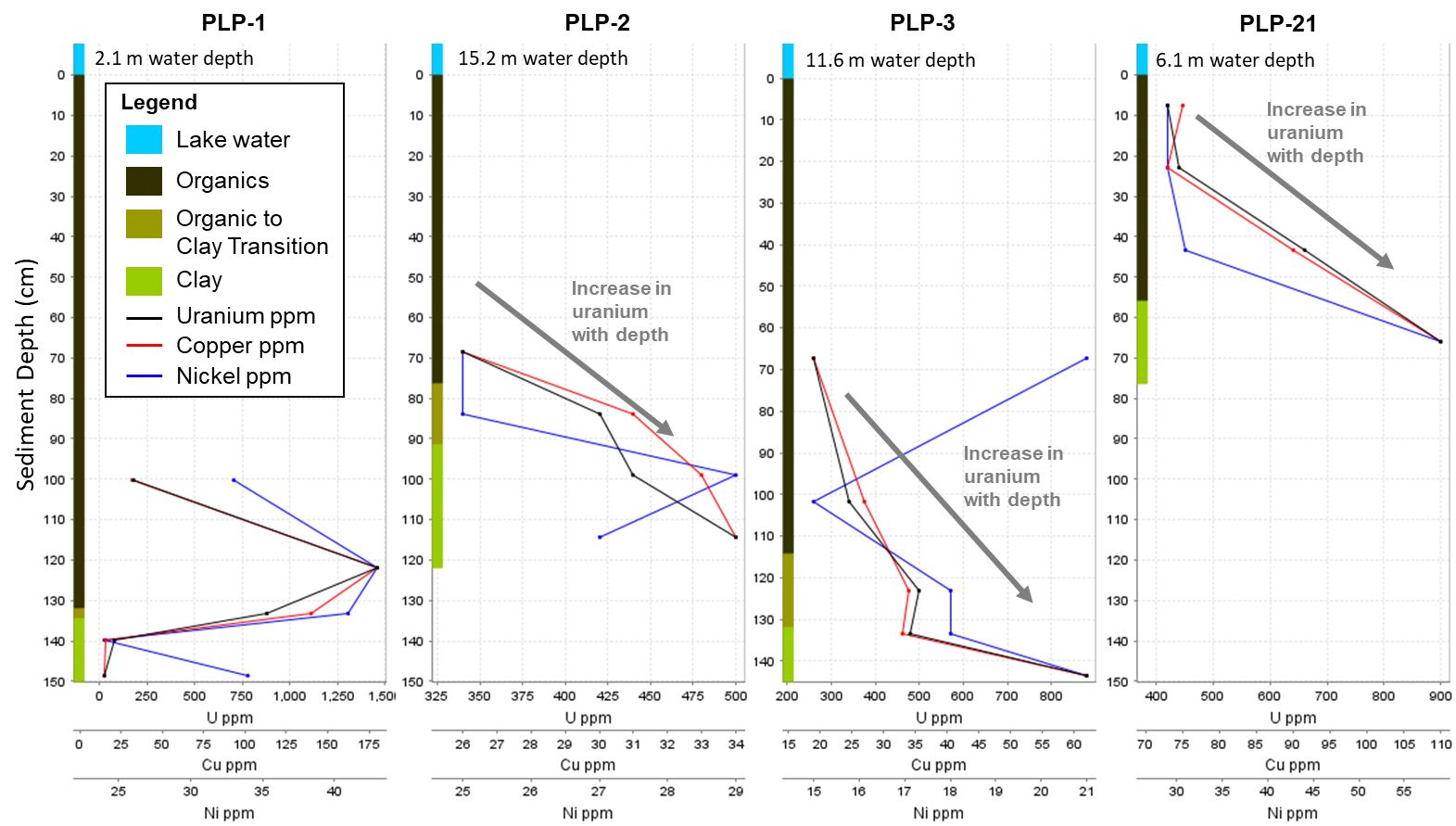
Figure 2: Historical Lake Sediment Pipe Core Results.
Rock chip sampling, restricted to available outcrop, was completed along select traverses and near lakes with uranium sediment anomalies to identify potential bedrock sources. While one encouraging value of 140 ppm U was received, the remainder of the values were relatively low with an overall average of 7 ppm U (Table 1). These values are within the typical ranges of average abundances within granitic rocks of 3 to 5 ppm U (Levinson, 1974).
Unable to locate a bedrock source (i.e. a uranium deposit) from surface prospecting, historical operators postulated that the uranium anomalism in lake sediments could derive from leaching of uranium from a regional background of rocks with above average concentrations in uranium, however no such rocks were discovered within the catchment areas of the anomalous lakes.
More recent exploration work was completed by historical operators between 2007 and 2015. Work comprised airborne geophysical surveying, including radiometrics, magnetics and electromagnetics (XDS-VLF-EM). These surveys identified numerous radioactively elevated (uranium) zones, significant structural lineaments, and shallow conductive features possibly representing faults and/or graphitic units. Very limited follow-up field work was completed, including reconnaissance rock chip sampling (total of 15 samples) and localized scintillometer prospecting. Results were highlighted by a rock chip sample of sheared granitic outcrop containing 1,870 ppm U collected along a northwesterly trending fault/pegmatite zone, which extends beneath Perron Lake. The remainder of the rock chip samples uranium values were typically low and broadly consistent with samples collected during the late 1970’s, again failing to locate a source for the exceptionally high uranium anomalism.
Geology
The Project is located approximately 30 kilometres north of the present-day margin of the Athabasca Basin sandstones. Basement geology comprises Precambrian pelitic schists and gneiss that have been intruded by post-tectonic granites, granodiorites and pegmatitic granites. Outcrop exposure is common, but significant areas are covered by thin glacial deposits, muskeg/swamps or small lakes.
Historical prospecting work during the late 1970’s identified graphite-rich lithological units, which are typically soft and weather preferentially, occurring in valleys with surficial cover. These graphite-rich units would therefore not have been properly mapped/prospected and would form prime exploration targets for Athabasca Basin-style, high-grade, basement-hosted uranium in accordance with more recent exploration models.
At the southern extent of the Project, six kilometres of prospective strike length is present along the Grease River Shear Zone (“GRSZ”), a crustal-scale structural corridor, including major structural splays that trend northeastward through the Project area for up to 10 kilometres. Numerous other prospective structural zones have been identified throughout the Project area, trending northeast and northwest, all of which could provide suitable settings for Athabasca Basin-style basement-hosted mineralization or Rössing-style mineralization. Prospective structural zones typically manifest as low-lying areas (negatively weathered) and are covered by glacial deposits, muskeg/swamps or small lakes, thus masking potential mineralization from historical radiometric survey and surface prospecting.
Next Steps
The source of the exceptionally high uranium anomalism in lake sediments and muskeg remains unresolved and a modern, systematic exploration approach is warranted to develop targets for ground follow-up and drill testing. Next steps are planned to include:
- Desk-top Prioritization of Target Areas: Detailed integrated interpretation of existing historical datasets, regional government data, and satellite imagery to delineate potential target areas, including the identification of favorable lithological and structural settings for Athabasca Basin-style basement-hosted mineralization or Rössing-style mineralization.
- Field Data Verification and Investigation: Verification of historical datasets is planned, to include ground-truthing of uranium anomalies. Scope of work to include scintillometer surveying and geochemical sampling.
- Drill Target Definition: Drill targets are expected to be defined through high-resolution airborne EM surveying (e.g. VTEMTM), followed by geological mapping and systematic ground geochemical and geophysical survey, as applicable.
Similar to other recently announced uranium projects, Fortune Bay may seek to find a suitable partner to advance the Project through an earn-in, or similar agreement, that provides Fortune Bay with upside in future discovery.
Technical Disclosure
The historical results presented here have not been verified and there is a risk that any future confirmation work and exploration may produce results that substantially differ from the historical results. These results have been captured from Saskatchewan Mineral Assessment Database (“SMAD”) reporting as available and may be incomplete or subject to minor location inaccuracies. The Company considers these historical results relevant to assess the mineralization and economic potential of the property.
Sources of information include:
- Work completed during the late 1970’s was undertaken by the Saskatchewan Mining Development Corp. (SMAD reference 74O07-0032) and by Uranerz Exploration and Mining Limited (SMAD references 74O09-0003, 74O09-0004, 74O09-0019 and 74O09-0020).
- Work completed between 2007 and 2015 was undertaken by CanAlaska Uranium Ltd. (SMAD references 74O09-0023,74O09-0024, 74O08-0076) and by Fission 3.0 Corp. (SMAD reference MAW01857).
- Regional lake sediment data is derived from the Geological Survey of Canada (“GSC”) digital compilation dataset, published 20 November, 2019 and most recently modified 9 November, 2023, available at the following link: https://open.canada.ca/data/dataset/0199fc8a-75bc-16cc-189d-4d88af556030, which contains information licensed under the Government of Saskatchewan Standard Unrestricted Use Data Licence (Version 2.0).
- Levinson A.A. (1974), Introduction to Exploration Geochemistry. ISBN 10: 0915834014 / ISBN 13: 9780915834013. Published by Applied Publishing Ltd., Wilmette.
Qualified Person
The technical and scientific information presented here has been reviewed and approved by Gareth Garlick, P.Geo., Technical Director of the Company, who is a Qualified Person as defined by NI 43-101. Mr. Garlick is an employee of Fortune Bay and is not independent of the Company under NI 43-101.
Cautionary Statements
Information set forth on this webpage may contain forward-looking statements that are based on assumptions as of the date of posting. The reader is referred to the cautionary language contained within the respective Project’s News Releases, in addition to this website’s Terms of Use specifically including Forward Looking Statements.